Rara, Mugu, Dolpo Trek
Enquiry For - Rara, Mugu, Dolpo Trek


Athletic level of trekking trips cover elevation of 5000m or few meters up level of trails with side trips to higher elevations. Measured to be harder therefore training for fitness and good health conditions are necessary. The person who are suffering from asthma, high blood pressure, heart disease or intricate medical conditions hikers are not recommended.


Most remote and some of the most challenging treks are found beyond mountains over 8,000 m like Dhaulagiri and Annapurna in the northwest of Nepal. Sparsely populated villages, challenging valleys, and ancient village monasteries enchant trekkers around the world. It is one of the most virgin treks in Nepal.
Villagers are goat and yak herds in the higher mountain regions. They have some of the ancient monasteries of the country to welcome you. The unparalleled views from the high mountain passes are breathtaking for anyone.
Arrival in Kathmandu Airport and transfer to hotel
25 minutes
Transfer to Kathmandu Airport for a flight to Nepalgunj.
Nepalgunj, a hot western city in Nepal, shares international border with India. Stay in Nepalgunj.
50 minutes
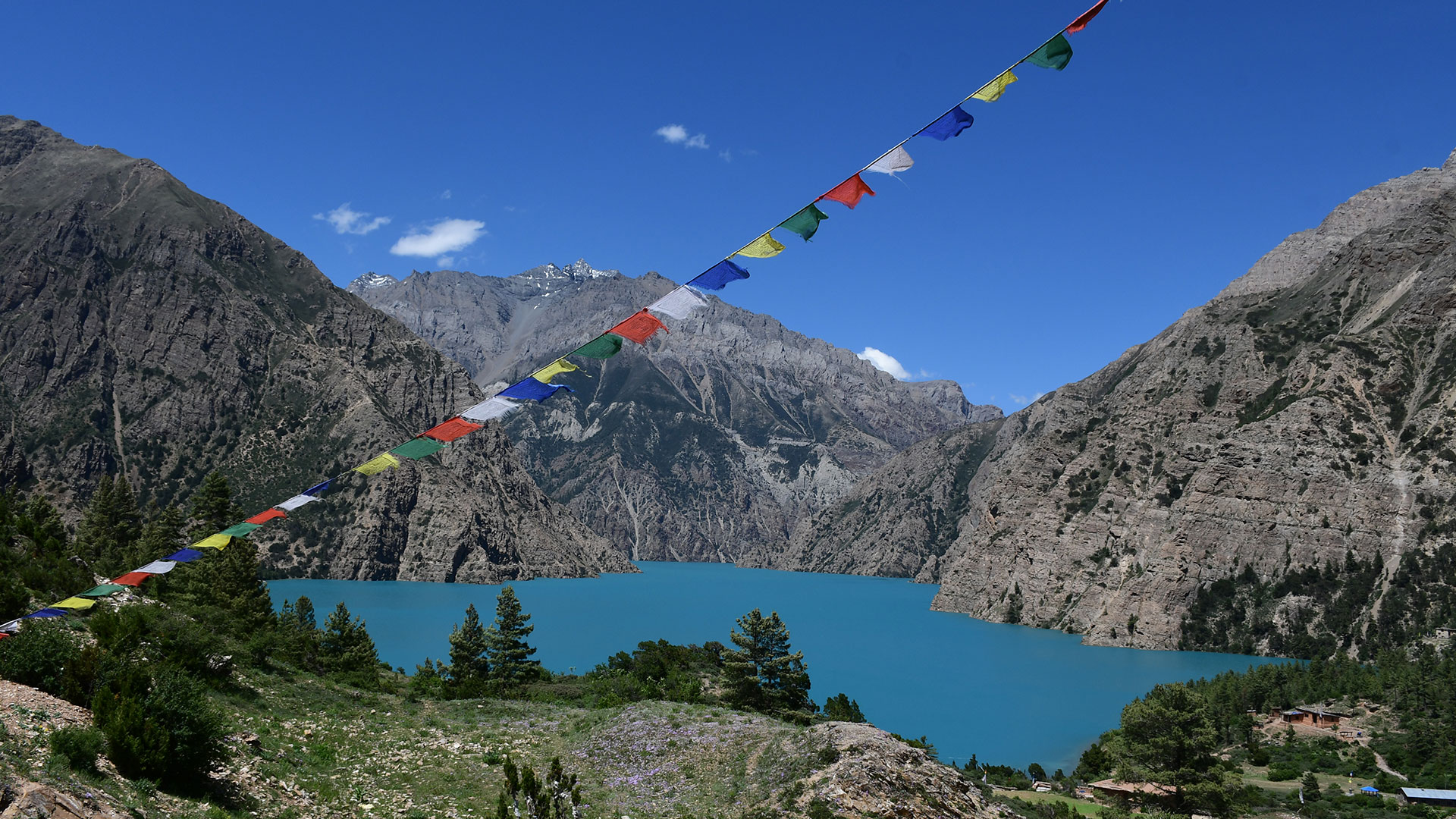
After breakfast in Nepalgunj, a 40-minutes flight takes you to Talcha airport in Mugu. Ascend over the stepping stones and walk through the pine and mixed forest and reach a ridge and descent a bit to see the magnificent view of the biggest freshwater lake in Nepal.
We walk along the lake and find a safe camping site for the stop. We meet the entire trekking team there.
Ascent 550 m - descent 220 m
4-5 hours
We begin to return the same way back for a few minutes. We turn left and ascend on the ridge a bit and descend for a couple hours to reach Gamgadhi town. The headquarter of Mugu District has banks, schools and college. Descend after the town till the bridge over a stream and continue to walk gently. We see a big river of Karnali by the side. This probably is the only river in Nepal flowing from Mt. Kailash. We trek pass many smaller villages and take our lunch on the way. Reach Lumsa Village and camp at a local school.
Ascent 380 m - descent 1,400 m
6-7 hours
Gentle walk and reach Chala Village. We see a water mill on the way. It is a point to grind flours of corn, barley, malt and rice for villagers around and for the caravan. We trek along the stream and have lunch on the way. We continue to trek to Phale.
Ascent 1000 m - descent 530 m
6-7 hours
We trek along the Mugu Karnali stream, cross it and continue trek. We see another river of Namlang coming from Kanjirowa mountain.
Continue trek and lunch on the way. Trek along the river, cross the river and ascend to reach to a monastery. We camp at the monastery complex at Tiyar.
Ascent 400 m - descent 300 m
5-6 hours
We return the same way back for a few minutes to join the route to
Salenchaur Kharka. Gentle ascend through the forest along the stream. The trail observes less number of foreign tourists. On the way, we can see some nomadic traders. Lunch and continue our trek along the stream and narrow forest to reach to a more open space of Salenchaur Kharka.
Ascent 800 m - descent 300 m
5-6 hours
A day of hiking and acclimatization. It is a day for exploration. We have a packed lunch for the day while exploring Mugu village. We walk along the river. We have small tea stalls on the way where we can taste local tea. We have time to visit a park and see the statue of Buddha. We trek back to camp.
Ascent 630 m - descent 630 m
5-6 hours
We cross the stream of Mugu Khola, descend a bit and turn left and to reach Chhyam Khola. Ascending walk the narrow trail along the stream and cross Babar Khola stream. We turn right for a few minutes to reach the open area of Thajuchaur. It is a wonderful pasteurland. We camp at Thajuchaur.
Ascent 1,225 m - descent 100 m
6-7 hours
Begin little early in the morning, ascend gently to begin and walk over to rocky and moraine parts to Chyrago La pass in a few hours. We have our packed lunch on the way.
Descent steep for a couple of hours. It is another part of the trek where we need to be extra careful and strictly follow the instruction of the trekking guide. Reach the bed of the stream and descend further gently till Takla Khola. Camp by the stream bed.
Ascent 1,100 m - descent 1,365 m
7-8 hours
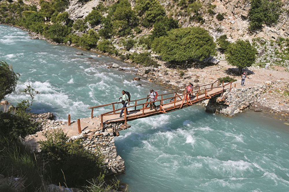
Cross Takla Khola over the wooden bridge, turn left and ascend through a narrow trail for a couple of hours. Gentle ascend over the ridge. We see the mountains in Tibet and open valley. We continue to walk on the trail for an hour and descend steeply to a river bed of Kaitpuchonam Khola to have our lunch. We cross the stream. If you are lucky we may find the wooden bridge otherwise we need to make a temporary bridge to cross the stream. There is a steep ascend for half an hour and descend Chyandi Khola. Walk along the Chyandi Khola and ascend gently to find the open valley and the summit of the mountains around. We camp by the bank of Chyandi Khola.
Ascent 1,450 m - descent 400 m
6-7 hours
Begin little early in the morning with packed lunches. Gentle ascend to begin and then steep ascend during the day. We cross Yala La Pass. Descend for a couple of hours to a stream bed of Swaksa Khola. We trek along the stream to continue walking. We reach Pung Kharka in about two hours. Camp on Pung Kharka.
Ascent 1,350 m - descent 1,100 m
7-8 hours
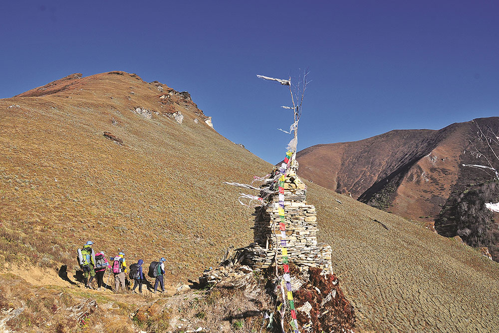
We prepare ourselves for the longest day of trekking in the entire tour. We begin the trek early in the morning and carry our packed lunch. We trek along the Swaksa Khola and turn right to begin ascending for a couple of hours. We reach the Ridge Pass. In a few minutes of descend and a half an hour of ascend takes you to Ngingma Gyaltsen Pass. We trek down over the rocky moraine through the ridge of the mountain for a few hours, turn left with gentle walk for an hour and find many prayers wheels on the stone. We trek down through the zigzag trail to Pho Village. It is the first village of the district of Dolpa.
Ascent 1,100 m - descent 1,700 m
8-9 hours
Rest day or a day to explore the surrounding.
Descend for a couple of hours to start the day. Reach Tora Khola which is connected with Mugu Karnali River. We cross the bridge and pass through the two big stones and continue to walk to find a cave. Lunch on the way. Ascend again for three to four hours to reach Yambur La pass. After the pass, we need to walk down a bit for a couple of hours to the village of Bhijer Village. There is a monastery and a school which is funded by French NGOs.
Ascent 1,200 m - descent 1,425 m
6-7 hours
We follow the stream of Yamchho Khola and gentle ascend to Nangla La Phedi.
Ascent 780 m and descent 100 m
4 hours
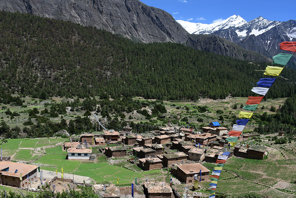
Gentle ascend to reach Nangla Pass. From the pass, we can see Dhaulagiri and other peaks. We descend for an hour and turn right to continue walking ups and downs till the ridge of Saldang. When you reach there you see the many houses of Saldang. We trek down to Saldang village.
Ascent 840 m - descent 1,410 m
6-7 hours
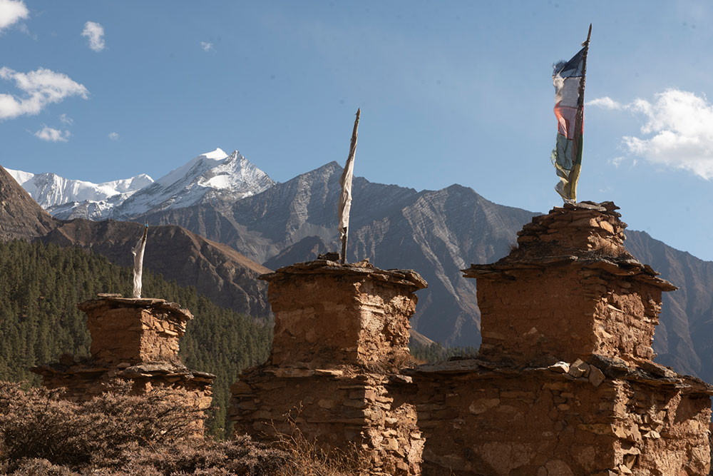
Visit the village and the monastery in the morning. After lunch, we continue to Chaa Gaon. On the easy way, we see chhortens and prayer wheels (mani walls). It is a small village where we will spend an overnight.
Ascent 160 m and descent 30 m
3 hours
Gentle ascend along with the Dachun Khola stream. We cross the wooden bridge and reach Rakyo Village and pass through the narrow valley and follow again to cross the stream from time to time. We often will need to ready our sandals to cross the stream. We reach Darsuna Dobhan and cross the river, turn left and have our lunch. We follow the river again, cross the river, turn right and ascend to reach Jyanta La Phedi Base Camp.
Ascent 900 m - descent 100 m
An easy ascent to reach the wide pass of Jyanta La. Gentle and trek along the stream Tarak. The magnificent view of Dhaulagiri can be seen. We descent to Tokyu village and reach Tarap valley and the villages on the way. We see Crystal Mountain School supported by French assistance on the way. We camp at Dho Village.
It is a wide village. We can see alpine valleys and wonderful Himalayan landscape around. It is a big village with Tibetan influence.
Ascent 350 m - descent 1,090 m
6-7 hours
A morning of rest, have a shower and wash clothes. A day of exploration day. We visit local families, monasteries and may visit school with French association.
7-8 hours
Gentle trek to begin and cross a stream Dho Khola. We walk along the stream for an hour. We cross the stream once again and enter Schipshok village. We visit a Ngingma Pa monastery and then a Bon monastery and then continue to trek and cross the same stream once again. A few hours of walking will take us to a narrow valley. We have lunch on the way. After lunch, we ascend gently to Jhyarkoi La Phedi.
Ascent 800 m - descent 100 m
5-6 hours
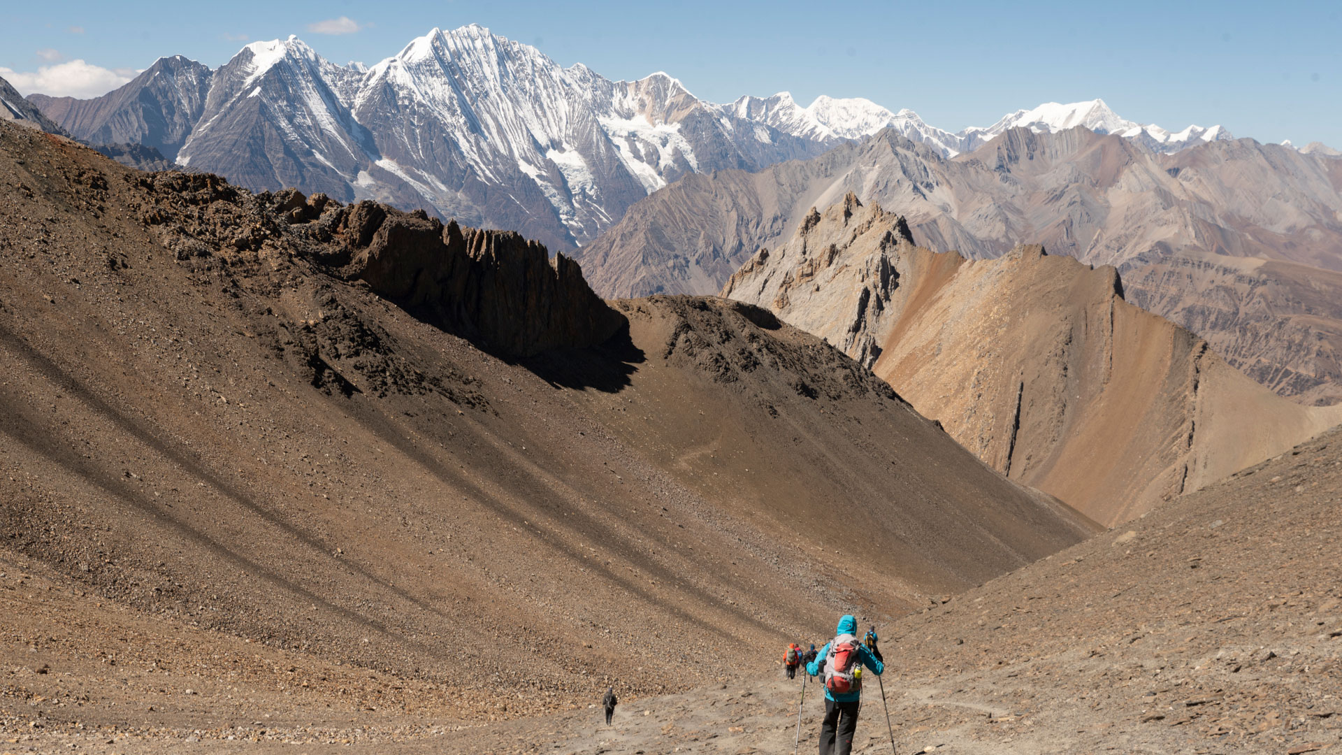
We begin the day a little early due to our destination to a mountain pass. Steep ascend for a hour, then gentle trek to cross a stream and then a steep ascend once again for a couple of hours to reach to a ridge and then turn right to view Dhaulagiri, Churen Himal and other mountains above 7,000 m. It is a great reward to see the fantastic mountain view after a hard work. We arrive at Jharkoi La Pass.
Gentle descend from Jharkoi La Pass and enter into another valley. We have a packed-lunch on the way. We descend further and turn right over the slope to reach Lajar Kharka. We see nomadic lifestyle of Nepali of Tibetan origin. We can see the yaks, horses, sheep and goats during the day.
Ascent 700 m - descent 720 m
5-6 hours
Gentle ascent to begin the day from Lajar Kharka for around 90 minutes, we reach Mola La. It is a good viewing point to see range of Dhaulagiri and many more mountains. We descend gently and turn left to continue for a couple of hours to reach Chharkha village. This is the last village in the region. The next village to it is either villages in the Mustang region or Tibet.
Ascent 400 m - descent 850 m
5-6 hours
Gentle walk to begin, cross the stream of Barbung and ascending walk along the stream for an hour and cross the Mulung Khola bridge. Ascend further and turn right where we need to walk through the narrow passage and cross the river multiple of times. We have lunch on the way. We have a camp at the bank of Mulung Khola.
Ascent 750 m - descent 200 m
6-7 hours
Gentle ascend till Nirwa La pass. Continue to ascend over the alpine slope to Jungben La. This is the highest pass of the entire trek. We can see the valley of Kali Gandaki and surrounding mountains from the top. Turning left, we descend to a stream and cross the river to continue a few ups and downs and reach Kok La pass, another mountain pass on the way. We descent steep from the point for a few hours to the bed of the stream. We need to be very careful and strictly follow the instruction of the trekking guide. We cross the suspension bridge over the Ghandang Ghuldung Khola and ascend for a few minute to reach to our camping site at an open ground.
Ascent 780 m - descent 1,340 m
7-8 hours
We begin the day with a gentle ascent and continue walking with several ups and downs. We see Ghok village during the day. We reach Sangta Village and have our lunch there. We visit the village. We ascend further for an hour and continue walking over the graveled road for an hour. We reach to an open ground where we camp for the day. We see the colorful landscape of Mustang Valley and surrounding mountains.
Ascent 250 m - descent 700 m
6-7 hours
We need to trek over the trail or over the road. We reach to a ridge from where we have beautiful views of Mt. Tilicho, Nilgiri, Dhaulagiri and many more mountains. We descend to the bed of Kali Gandaki River and reach Kagbeni. Lunch in the Kagbeni and visit a monastery.
We drive to Jomsom.
Ascent 160 m - descent 1,530 m
3-4 hours
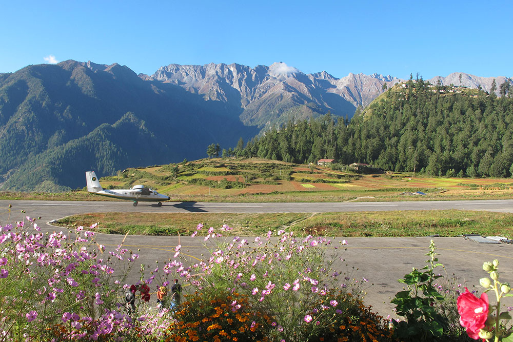
After breakfast in Jomsom fly back to Pokhara and take another flight back to capital city Kathmandu.
Transfer to hotel.
20 minutes
25 minutes
Options for sightseeing to World Heritage Sites/ayurvedic massage or rest in Kathmandu.
Kathmandu Valley has, perhaps, the densest concentration of UNESCO World Heritage Sites. Seven UNESCO WHS of Bhaktapur Durbar Square, Boudhha, Pashupati, Patan Durbar Square, Swoyambhu, Kathmandu Durbar Square and Changu Narayan Temple are framed within 400 sq km. For a full day tour exploring three UNESCO WHS are comfortably possible. For example, you may choose Bhaktapur Durbar Square (a medieval city square), Pashupati (the holiest Hindu temple) and Bouddha (a Buddhist stupa) for a smart mix of culture and architecture with two major religious (Buddhism and Hinduism) sites of Nepal.
Transfer to the airport in time to secure a flight back home
Let our experts guide you to your perfect Holiday.
+977-1-4531445

